Drone Observations for Tank Farm Inspections
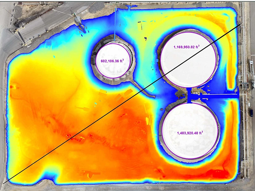
Refinery tanks
drone berm calculations

The Challenge

The client, a large independent petroleum-refining company, sought an environmental firm to provide tank inspection services for their extensive refining facility’s aboveground storage tank (AST) field. As these inspection services would require working at heights, which poses abundant risks to workers, the client proposed the use of small unmanned aircraft systems (sUAS), or drones as an alternative safer and more efficient method for accomplishing the tank roof inspections.

GES Solution

GES was engaged to demonstrate the capabilities of drones to improve safety, data quality, and task efficiency during mandatory inspection tasks. Work included updating a site-specific regulatory document, which detailed the plan for Spill Prevention Countermeasure and Control (SPCC). To update this SPCC plan, calculation of the secondary containment volume was required. Inspection of the outer layers of the ASTs for holes or damages was required.

The client’s safety, inspection, and technology management personnel attended the drone demonstration to observe the process of collecting inspection data to accomplish these tasks with improved safety, data quality, and task efficiency.

All flights were pre-programmed, field-verified, and fully automated, ensuring data were collected at required locations and would be repeatable, allowing for accurate comparisons over time with multiple site visits.

The use of advanced sensors, such as thermal infrared and optical zoom cameras, allowed the pilots to inspect for issues not normally seen in the visible spectrum of light or from eye-level. This process of data collection, known as photogrammetry, combines hundreds of overlapping, high-resolution (4K) images to generate an orthomosaic map, a site map without photographic distortion that is geographically accurate. Photogrammetric models are used to generate containment volume models based on spatial measurements of millions of data points; the traditional method of calculation is based on theoretical design drawings and is often inaccurate in our findings.

Ground control points (GCP) were established using survey GPS and visual markers. This approach, in combination with GIS analysis from our Environmental Informatics (EI) group, improved site model accuracy.

Client Benefits

GES’ use of the sUAS data-collection platform, utilizing multiple types of sensors and photogrammetry, provided the client with risk mitigation, time and cost savings, and technological advantages over the traditional method of working at heights. If expanded facility-wide, the use of drones would drastically reduce the time to complete AST and infrastructure inspection, while simultaneously improving the quality of the inspection.

Photogrammetric models documented tank conditions, which can be compared with subsequent inspections to monitor progress in repair and maintenance, thereby making the decision process easier and more effective. In future visits to improve other on-site tasks, thermal cameras can be used to measure fill levels or identify major tank leaks.

Collection of photos and the digitization of documentation aided in site evaluation and assisted in recertification of SPCC plans to maintain facility compliance.